
Planning & Zoning
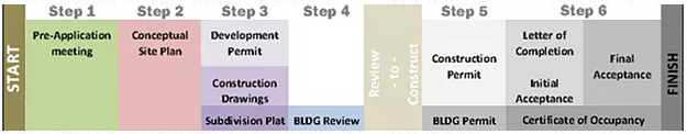
The Vinita Planning & Development Commission guides the physical development of the city by preserving our historic sites, planning what can be built where, and ensuring safe construction of buildings and infrastructure. A host of advisory and governing bodies of residents as well as elected officials provide oversight as the city grows and needs arise. The process is governed through development and enforcement of city codes and ordinances.
Zoning
Zoning is the set of rules that govern how land may be used and developed in Oklahoma City. Zoning is necessary to protect the health, safety, and welfare of the community and is a tool used to implement the City’s comprehensive plan.
The zoning map shows how all land within the City of Vinita is zoned. The official zoning map for the City of Vinita is accessible HERE.
To check on zoning, details, and ownership of specific properties in Vinita and Craig County, click to go to ActDataScout.com for search database and interactive map.
Zoning Districts
Each zoning district has standards for how land may be developed, including permitted uses, lot sizes, densities, setbacks, landscaping, parking, screening, and other regulations. The standards are contained within The City of Vinita Zoning and Planning Code, found in Chapter 10 of the Vinita Municipal Code. Click HERE to go to our interactive Municipal Code information with Sterling Codifiers. Just click on Chapter 10 to browse Zoning District information.
Please note there are several areas within Vinita City Limits that require design approval.
Subdivision
Subdivision is the act of dividing land. Similar to zoning, subdivision regulation is a land use control used to implement the City’s comprehensive plan. Typical actions include the division of land into two or more lots, tracts or parcels; the dedication of a road, highway or street through a tract of land regardless of area; or re-subdivision of land divided or platted into lots, tracts, or parcels.